Viewing Oblique Imagery (Where Available)
Learn how to view oblique imagery (not available on all Online Auditor websites).
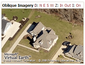
Oblique Imagery is an exciting new technology made possible by Microsoft Virtual Earth and Pictometry. Oblique images are high resolution views of earth's surface at a slight angle where objects can be viewed from each direction. To learn how to view oblique imagery on this website, read from the topics below.
Viewing Oblique Images
The oblique imagery window will only be displayed once you have zoomed in past a certain extent. This way, the detail shown in the oblique imagery matches the detail shown on the main map. Once the oblique imagery window is displayed, additional tools are available.
Changing Direction
You can view objects from each of the four directions. Click 'N', 'E', 'S', 'W' to view north, east, south and west directions respectively. Note, clicking 'N' will show you the south side of any objects in the image because you'd be looking north.
Zooming In
Two zoom levels are available in the oblique imagery window, 'Out' and 'In'. The default zoom level is Out.
Launching Interactive Mode
Click 'I' to launch Interactive Mode. Interactive Mode will pop up a new, larger window and allow you to use more advanced tools to interact with the map.